Month: November 2010

OSU Ships Underway Data System

One of the highlights of going to the RVTEC meeting is getting to hear about some of the cool projects that are underway at the various institutions. One talk that caught my attention was the SUDS system, an NSF sponsored project that was given by the techs at Oregon State University.

I talked David O’Gorman and Toby Martin into doing a quick rundown on their SUDS system on camera during one of the breaks. SUDS is an acronym for the Ships Underway Data System, which consists of software and two data acquisition boards that they designed in-house – one analog and one digital. Each board can be programmed with metadata about the sensors that are attached to them. When the boards are plugged into the ships network they broadcasting XML data packets which include both data and metadata about the data via UDP for a back-end data acquisition to capture and store. For redundancy, there can be multiple acquisition systems on the network as well I’m told.

The data acquisition cards can be either powered directly or via POE (Power Over Ethernet). They can also supply power to the sensor if needed. The digital cards can accept RS232 and RS485. The analog has 4 differential input channels which can do 0-5v on two of the channels and 0-15v on the other two and range from 600Hz to 20kHz input signals.

Their website has links to a PDF of the presentationthey did at the 2010 UNOLS RVTEC meeting as well as various examples of data packets that the system broadcasts. Definitely something that could be quite useful to handle the ever-changing data acquisition needs on today’s research vessels. I look forward to learning more about the SUDS system in the days to come.

UNOLS RVTEC 2010

RV HSBC Atlantic Explorer

RV HSBC Atlantic Explorer

Just got back from the 2010 UNOLS RVTEC meeting, which was held at the Bermuda Institute of Ocean Science (BIOS) – home of the RV HSBC Atlantic Explorer.

(Acronym Police: UNOLS = University-National Oceanographic Laboratory System and RVTEC = Research Vessel Technical Enhancement Committee).

For those unfamiliar with RVTEC, it is a committee organized around 1992 to “provide a forum for discussion among the technical support groups of the National Oceanographic Fleet” in order to “promote the scientific productivity of research programs that make use of research vessels and oceanographic facilities and to foster activities that enhance technical support for sea-going scientific programs” as listed in Annex V of the UNOLS charter. Membership is extended to UNOLS member institutions but “Participation shall be open to technical and scientific personnel at UNOLS and non-UNOLS organizations”.

The meeting agenda was pretty intense and we were pretty much straight out from Monday through Friday afternoon. There were a lot of scary smart people in the room doing some pretty amazing things in support of science operations at their respective institutions. I tried to compile a list of Tech Links on the ResearchVessels.org site to make it easier to find some of the various resources that were discussed at the meeting. I did the same thing at last years RVTEC meeting in Seattle but some additions and corrections were needed based on feedback from the members. I’m hoping that I’ll be able to obtain funding to attend next years meeting and perhaps the upcoming Inmartech meeting (look for a post on Inmartech soon).

I shot some video, made some fantastic contacts and had some interesting discussions at this years RVTEC meeting. If all goes smoothly, I’ll have a couple of new blog entries online this week to help share some of the wealth of knowledge.

3DVista Panoramic Tour of the Sharp

I tinkered around with a demo copy of the 3DVista Stitcher and 3DVista Show 3.0 to push its capabilities a tad. I touched on the packages in a previous blog post about the Global Visualization Lab where I did a simple panorama of the room. The wheels started turning and we decided to push the envelope a little and create a series of panoramic views of the RV Hugh R Sharp as a proof of concept for an online virtual tour of a research vessel.
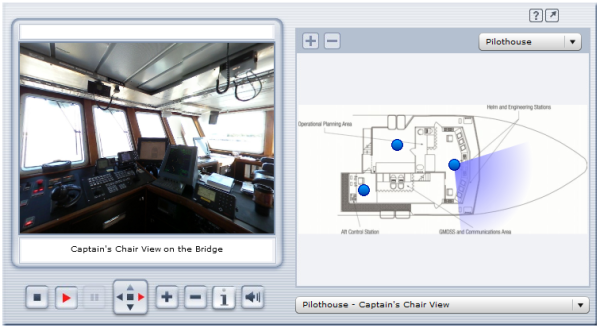
Panoramic Tour of the RV Hugh R Sharp

Click on this image to visit the proof-of-concept panorama…

The image above is a screen shot of the proof-of-concept panoramic tour we came up with. Click the image above or this hyperlink to visit the actual panoramic tour. The pane on the left shows an interactive panorama of the various points of interest on the ship. The right-hand pane shows a scan of the deck and compartment that the panorama represents. If there is no user action, the tour will cycle through a complete 360 view of each panorama and will move onto the next panorama in the list if nothing is clicked. There are two drop-d0wns to the right, one above the deck layout to select a specific panorama and one below it to select a specific panorama.

A really cool feature of the product is the ability to take the panorama full-screen for a more immersive experience. To do so, just click on the arrow button in the top-right-hand corner next to the question mark symbol. Once in full-screen mode, you can easily cycle through the various pano’s by mousing over them near the bottom of the screen.

The 3DVista Show software allows you to insert hot-spots into the panorama’s as well that can either link to other pages/sites or to include an audio clip into the mix. This makes it quite easy to include additional information about a specific area or feature. I inserted an animated arrow pointing to the Multibeam Operator Station on the Main Deck -> Multibeam Tech Area that links out to the Reson Seabat 8101 Multibeam Echosounder posting.
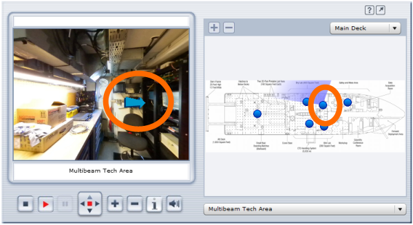
Multibeam Tech Pano

The mind races with the various uses for this type of technology. It allows for mobility impaired individuals and class groups to tour a space that they’d ordinarily be unable to access. It also allows scientists to “look around” and get a feel for the spaces that they’d be using when they come onboard a vessel. For a future project, I’d like to get support do some panorama’s both inside and outside of the various UNOLS lab vans that would allow scientists to virtually stand in the lab vans and walk around them to see how they’re laid out. 3D panorama’s of research sites in remote locations like the arctic and antarctic also come to mind as does tours of mineral sample and other collections with hotspots included for the various specimens for links to additional information. The application of this tech abounds.

I talked with the folks at 3DVista and it looks like they offer a 15% academic discount for the software so be sure to ask about if if you’re going to purchase it. They also list a one-shot 360 degree pano lens and adapters to make shooting the digital pics a little easier. We used a 180 degree fish-eye lens for our pano shots, which means we did 3 shots at each location 120 degrees off from one-another and stitched them together with the 3DVista Stitcher program.

Many thanks to Lisa Tossey for taking the photos and getting this project rolling. I posted this as an unpolished proof-of-concept version. I look for the ready-for-prime-time panorama that she comes up with for the CEOE site. I also look forward to seeing any cool panoramas that are out there for research projects. Be sure to share your links.

© 2024 Ocean Bytes Blog

Theme by Anders NorenUp ↑