Some students and I went on a road trip to Rutgers University in New Jersey and then ended up heading up the coast to East Falmouth, Massachusetts to meet with the fine folks at Teledyne Webb Research. During a tour of the facilities, we were introduced to the APEX floats, whose data (through the ARGO program) the students were accessing for various projects in the ORB lab. James Truman, an engineer at Webb, graciously agreed to do a quick 101 overview of the APEX on camera.
Profiling floats like the APEX are able to sink or float by varying their internal volume. A standard equation for Buoyant Force is:
F(buoyant) = –pVg
where p=density of the fluid, V=volume of the object (in this case the float) and g=standard gravity (~9.81 N/kg). By adjusting the internal volume of the float by pumping fluids in and out of the interior, we are able to make the device either more or less buoyant. There’s a really neat cut-away animation on the UCSD Argo site that shows the guts of the units quite well.
Float technology has evolved rather quickly, with the original floats only serving as a mechanism for tracking deep ocean circulation – also called Lagrangian Drifters or ALACE (Autonomous Lagrangian Circulation Explorer) floats. They would pop up to the surface and transmit back their positions and the temperature at depth. Using the drifters last known position and its new position gave scientists an idea of how fast and in what direction the deep ocean currents were moving. Later these drifters were equipped with CTD sensors (Conductivity-Temperature-Depth) and they took sensor readings all the way up the water column and transmitted a “profile” reading back to the mother ship. These were called PALACE or “Profiling ALACE” floats (see WHOI’s site on ALACE, PALACE and SOLO Floats).
These predecessors bring us to the modern world of the ARGO Float fleet, which consists of APEX floats from Webb Research, the PROVOR floats from MARTEC and the SOLO floats from Scripps Institute of Oceanography. My understanding is that these floats dive to a depth of around 2000 meters and drift for 10 days and then float to the surface, profiling the water column along the way. They then communicate their readings via Iridium Satellite or the ARGO system and then dive again for another 10 days or so.
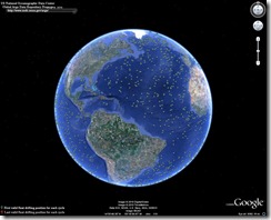
NOAA has a site called ARGO KMZ Files that makes it really easy to get started tracking ARGO floats and their data. You just need to install Google Earth first – which can be downloaded at: http://earth.google.com/. Below is a screen shot of the ARGO floats in the Atlantic.
Thanks again to James Truman and the awesome people at Webb Research for taking us under their wing and spending a lot of time showing us the ropes. It was an excellent experience that the students are still talking about.

